Property Record
229 Gum Tree Rd, Hilton Head Island, SC 29926


NEARBY LISTINGS FOR SALE OR LEASE
-
-
View all Hilton Head Island listings for lease on LoopNet.com
Property Detail
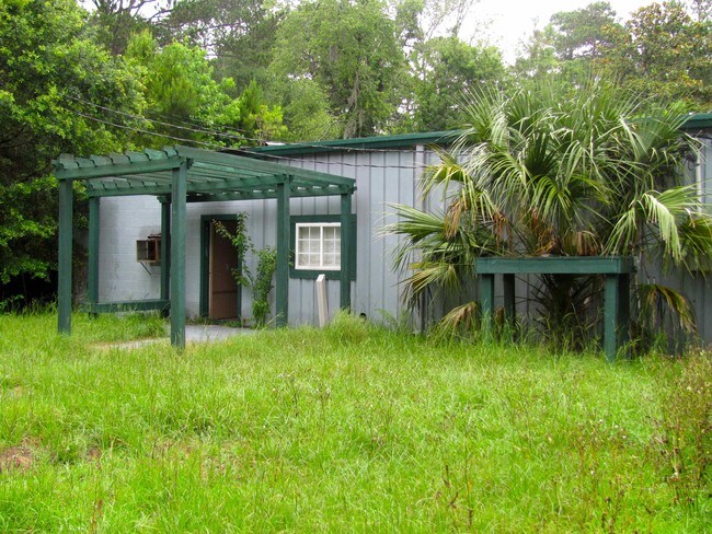
229 Gum Tree Rd
Hilton Head Island-Bluffton-Beaufort, SC
No.Hhi Suburban & Rural Comme
R510-003-000-025A-0000
PAR 3 PB21 P184 *TOT AC INCL 0.03 AC DRAINAGE ESMT PB73 P86
Commercialbuilding
Beaufort
2025
South Carolina
2024
0.70 AC
010500
Other Market Areas
5,000 SF
DEMOGRAPHICS near 229 Gum Tree Rd
1 Mile
3 Mile
5 Mile
2024 Total Population
4,593
20,095
42,304
2029 Population
5,048
22,370
48,441
Pop Growth 2024-2029
+ 9.91%
+ 11.32%
+ 14.51%
Average Age
49
50
52
2024 Total Households
1,968
8,578
18,930
HH Growth 2024-2029
+ 9.60%
+ 10.82%
+ 14.36%
Median Household Inc
$72,572
$88,667
$82,554
Avg Household Size
2.30
2.30
2.10
2024 Avg HH Vehicles
2.00
2.00
2.00
Median Home Value
$447,510
$494,837
$542,804
Median Year Built
1989
1992
1990
Nearby Places
Map Layers
Map Styles
 Street
 Aerial
- Restaurants
- Banks
- Shops
- Fitness
- Groceries
PUBLIC TRANSPORTATION
AIRPORT
Hilton Head
DRIVE
WALK
Distance
Hilton Head
9 min
4.3 mi
Savannah/Hilton Head International
DRIVE
WALK
Distance
Savannah/Hilton Head International
60 min
42.8 mi
Freight Ports
Georgia Ports - Savannah
DRIVE
WALK
Distance
Georgia Ports - Savannah
55 min
41.2 mi
SALE & LEASE HISTORY
LISTING DATE
SALE/LEASE

Sep 25, 2016
For Lease
Sep 23, 2016
For Sale
Nearby Properties
Address
Land Use
TOTAL SIZE
Lot Size
Zoning
Address
Land Use
TOTAL SIZE
Lot Size
Zoning
960 SF
3,900 AC
6106
Address
Land Use
TOTAL SIZE
Lot Size
Zoning
16,424 SF
13.89 AC
6615
Address
Land Use
TOTAL SIZE
Lot Size
Zoning
Address
Land Use
TOTAL SIZE
Lot Size
Zoning
145,864 SF
49.71 AC
6615
Address
Land Use
TOTAL SIZE
Lot Size
Zoning
187,534 SF
14.92 AC
6615
Address
Land Use
TOTAL SIZE
Lot Size
Zoning
980 SF
38.06 AC
6615
Address
Land Use
TOTAL SIZE
Lot Size
Zoning
123,912 SF
21.80 AC
6615
Address
Land Use
TOTAL SIZE
Lot Size
Zoning
133,565 SF
44 AC
6615
Address
Land Use
TOTAL SIZE
Lot Size
Zoning
7,488 SF
10 AC
6615
Address
Land Use
TOTAL SIZE
Lot Size
Zoning
31,200 SF
10.60 AC
6615
Address
Land Use
TOTAL SIZE
Lot Size
Zoning
93,782 SF
7.61 AC
6615
Address
Land Use
TOTAL SIZE
Lot Size
Zoning
71,118 SF
13.61 AC
6615
Address
Land Use
TOTAL SIZE
Lot Size
Zoning
57,094 SF
12.38 AC
6615
Address
Land Use
TOTAL SIZE
Lot Size
Zoning
13,380 SF
5.74 AC
6615
Address
Land Use
TOTAL SIZE
Lot Size
Zoning
45,195 SF
5.98 AC
6605
Address
Land Use
TOTAL SIZE
Lot Size
Zoning
19,729 SF
5.46 AC
6615
Address
Land Use
TOTAL SIZE
Lot Size
Zoning
13,680 SF
5.50 AC
6615
Address
Land Use
TOTAL SIZE
Lot Size
Zoning
10,164 SF
62.14 AC
6615
Address
Land Use
TOTAL SIZE
Lot Size
Zoning
35,880 SF
10.23 AC
6615
Address
Land Use
TOTAL SIZE
Lot Size
Zoning
1,440 SF
179.56 AC
6615
Address
Land Use
TOTAL SIZE
Lot Size
Zoning
13,920 SF
479.52 AC
6615
Address
Land Use
TOTAL SIZE
Lot Size
Zoning
7,153 SF
7.22 AC
6615
Address
Land Use
TOTAL SIZE
Lot Size
Zoning
9,848 SF
4.92 AC
6615
Address
Land Use
TOTAL SIZE
Lot Size
Zoning
2,666 SF
1.38 AC
6615
Address
Land Use
TOTAL SIZE
Lot Size
Zoning
10,424 SF
190.21 AC
6615
Address
Land Use
TOTAL SIZE
Lot Size
Zoning
75,380 SF
10 AC
6605
Address
Land Use
TOTAL SIZE
Lot Size
Zoning
12,417 SF
7.01 AC
6615
Address
Land Use
TOTAL SIZE
Lot Size
Zoning
27,000 SF
8.60 AC
6615
Address
Land Use
TOTAL SIZE
Lot Size
Zoning
75,336 SF
5.23 AC
6615
Address
Land Use
TOTAL SIZE
Lot Size
Zoning
14,453 SF
5.87 AC
6615
The World's #1 Commercial Real Estate Marketplace
Connect with us
© 2026 CoStar Group
The information above has been obtained from sources believed reliable. While we do not doubt its accuracy we have not verified it and make no guarantee, warranty or representation about it. It is your responsibility to independently confirm its accuracy and completeness. Any projections, opinions, assumptions, or estimates used are for example only and do not represent the current or future performance of the property. The value of this transaction to you depends on tax and other factors which should be evaluated by your tax, financial, and legal advisors. You and your advisors should conduct a careful, independent investigation of the property to determine to your satisfaction the suitability of the property for your needs.